
18 December 2011
12 November 2011
Study trip
Ruhr:
Key sites:
Landschaftspark and Zollverein are within Emscherpark
http://sustainablecities.dk/en/city-projects/cases/emscher-park-from-dereliction-to-scenic-landscapes
Landschaftspark Duisburg-Nord - http://en.landschaftspark.de/
Peter Latz website (change to English at bottom of page)
Gasometer Oberhausen - "Magic Places" exhibition
Zollverein - website
Ruhr Museum by OMA http://www.ruhrmuseum.de/
Zollverein School of Management and Design by SANAA - project architect's website
Essen
Aalto Theatre: website (in German)
Museum Folkwang by Chipperfield: museum website, AR article
Insel Hombroich - website (in German), Kulturkenner website (North Rhine-Westphalia events)
Siza and Finsterwalder pavilion: AR article
London places:
5 November 2011
Site work
Enjoy your sites: observe and investigate, draw out and explore the qualities that interest you. Document these qualities through drawing and photography and allow the process of recording to further your investigations, as well as articulating your interests. Consider the whole site, beyond the boundaries of the site to neighbours and context, as well as selected details. Here are some images from site and drawings to inspire you:

student site studies from top: Campo San Polo by Charanpal Matharu, 3-point site study by Nenad Djordjevic, Venice site plan by Marios Aphram
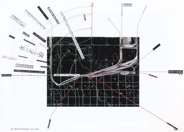
Rail Networks, from Taking Measures Across the American Landscape by Corner and MacLean

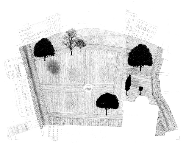
Belavali House site plan by Studio Mumbai

San Giorgio photomontage by Enric Miralles


Merced River, Yosemite Valley photocollage and Still Life Blue Guitar composite polaroid, both by David Hockney

Polyptich: Off Waterloo Bridge, by Jon Spencer

The Avro 1 triplane being tested on Walthamstow Marshes, 1909

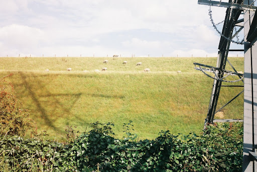
aerial photo of museum site showing previous waste incineration chimney, sewage filterbeds, railtracks and farmbuildings

derelict Warners building, Hawarden Road
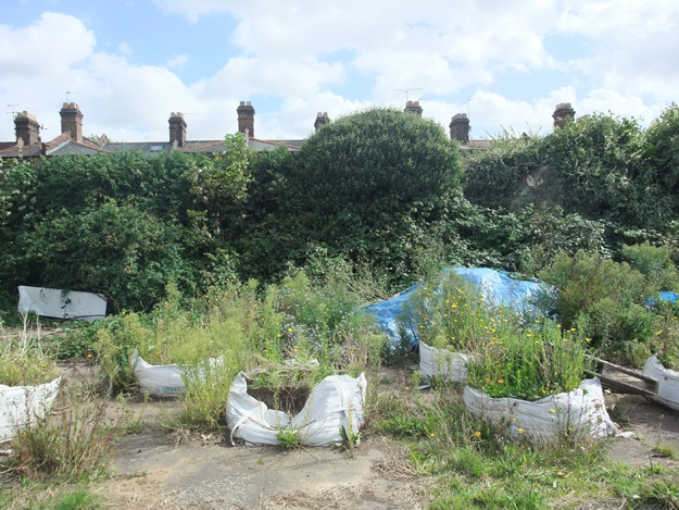

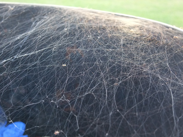
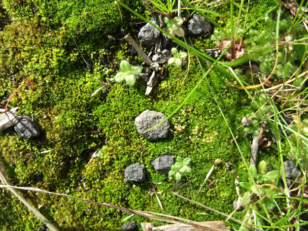


details from top: wildflowers in rubble sacks, flood channel and reservoir bank, spider webs in oil drum litter bin at Douglas Eyre, detail of ground at Walthamstow Pumphouse Museum, moss and lichen on Ferry Lane wall to train tracks and reservoirs
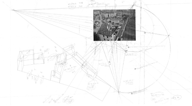
I recently came across some beautiful drawings by Perry Kupler:

Fast Twitch Site Plan by Perry Kulper
student site studies from top: Campo San Polo by Charanpal Matharu, 3-point site study by Nenad Djordjevic, Venice site plan by Marios Aphram
Rail Networks, from Taking Measures Across the American Landscape by Corner and MacLean
Belavali House site plan by Studio Mumbai
San Giorgio photomontage by Enric Miralles
Merced River, Yosemite Valley photocollage and Still Life Blue Guitar composite polaroid, both by David Hockney
Polyptich: Off Waterloo Bridge, by Jon Spencer
The Avro 1 triplane being tested on Walthamstow Marshes, 1909
aerial photo of museum site showing previous waste incineration chimney, sewage filterbeds, railtracks and farmbuildings
derelict Warners building, Hawarden Road
details from top: wildflowers in rubble sacks, flood channel and reservoir bank, spider webs in oil drum litter bin at Douglas Eyre, detail of ground at Walthamstow Pumphouse Museum, moss and lichen on Ferry Lane wall to train tracks and reservoirs
I recently came across some beautiful drawings by Perry Kupler:
Fast Twitch Site Plan by Perry Kulper
19 October 2011
Maps and other large drawings
Recent tutorials have touched on ways of mapping, in addition to the East drawings, here are some references that may be of interest:
BBC4 series Maps: Power, Plunder and Possession (three parts) and The Beauty of Maps (four parts) - both are in the library DVD collection under 791.4572 MAP and 791.4572 BEA
archive of Magnificent Maps exhibition at the British Library, book on order at the library
Mapping London: making sense of the city, by Simon Foxell [911.421 FOX]
London: a life in maps, by Peter Whitfield [911.421 WHI]
Liquid city, by Marc Atkins and Iain Sinclair [914.210485 ATK]
Historic Digimap, which you can access via your Athens account
MAPCO - online collection of historical maps of London, the Lea Valley starts to appear from 1800 onwards
Map Tube, an online map-sharing resource hosted by UCL

extract from Stanford’s Geological Library Map Of London And Its Suburbs 1878
This year's second prizewinner in the Jerwood Drawing Prize is Jessie Brennan for The Cut: a 5 metre long drawing of the Hackney Cut, the section of the Lee Navigation that runs alongside Hackney Wick, and that we walked along. The drawing is inspired by stories and oral histories of the place and plays with scale. The prize shortlist exhibition is on until the end of the month, go and see it. It's a major, open entry prize - meaning you can enter it next year. (One of the exhibitors is a recent UEL graduate.)


top: The Cut, by Jessie Brennan (Pencil on paper, 29.7 x 504 cm) and above: Detail from The Cut
A copy of two 12-metre long drawings of the north bank and south bank of the Thames by Matteo Pericoli are on display until the 26th October in the Gallery, top floor of Foyles bookshop. Incredibly they are drawn by hand on ordinary lightweight tracing paper rolls.

London Unfurled, preparatory work (photos and sketches) by Matteo Pericoli
BBC4 series Maps: Power, Plunder and Possession (three parts) and The Beauty of Maps (four parts) - both are in the library DVD collection under 791.4572 MAP and 791.4572 BEA
archive of Magnificent Maps exhibition at the British Library, book on order at the library
Mapping London: making sense of the city, by Simon Foxell [911.421 FOX]
London: a life in maps, by Peter Whitfield [911.421 WHI]
Liquid city, by Marc Atkins and Iain Sinclair [914.210485 ATK]
Historic Digimap, which you can access via your Athens account
MAPCO - online collection of historical maps of London, the Lea Valley starts to appear from 1800 onwards
Map Tube, an online map-sharing resource hosted by UCL
extract from Stanford’s Geological Library Map Of London And Its Suburbs 1878
This year's second prizewinner in the Jerwood Drawing Prize is Jessie Brennan for The Cut: a 5 metre long drawing of the Hackney Cut, the section of the Lee Navigation that runs alongside Hackney Wick, and that we walked along. The drawing is inspired by stories and oral histories of the place and plays with scale. The prize shortlist exhibition is on until the end of the month, go and see it. It's a major, open entry prize - meaning you can enter it next year. (One of the exhibitors is a recent UEL graduate.)
top: The Cut, by Jessie Brennan (Pencil on paper, 29.7 x 504 cm) and above: Detail from The Cut
A copy of two 12-metre long drawings of the north bank and south bank of the Thames by Matteo Pericoli are on display until the 26th October in the Gallery, top floor of Foyles bookshop. Incredibly they are drawn by hand on ordinary lightweight tracing paper rolls.
London Unfurled, preparatory work (photos and sketches) by Matteo Pericoli
17 October 2011
Manual
A new section Manual has been added under Information, regarding portfolios and process.
Relevantly, an extract from the East book Expressing Interest is available here, which discusses ways of drawing among other things (there are copies of the full book in the library)
They also quote Practical Exercises from one of my favourite texts: Species of Spaces by Georges Perec.

Relevantly, an extract from the East book Expressing Interest is available here, which discusses ways of drawing among other things (there are copies of the full book in the library)
The ‘thing on the table’ is usually a map, and we are talking about a place. We are trying to be as precise as possible. Every little granite sett, every name, every window might be important, and might help … in our understanding of where we’re going to. This is not the time to make judgements or to generalise, or for wishing that the world was more tidy or operated according to your ideas or design principles. Wanting to do this drawing – the desire and the process – changes the way I look at a site.
The drawing is an instrument that reveals or charts the specific conditions of a place with all its complexity, conflicts, contradictions – the banal as well as the sublime. Once this drawing exists, a commitment is made. The room is full of potential.
They also quote Practical Exercises from one of my favourite texts: Species of Spaces by Georges Perec.
Sketches for East Barking framework plan, by East
15 October 2011
Do the drawings and you win

12-13th October 2011: Mark Brearley, Eleanor Fawcett, Tom Holbrook, Alison Crawshaw
Links to more information on the guest speakers this week and the projects they presented:
East
Design for London
Olympic Park Legacy Company
5th Studio
muf
East London Green Grid at Design for London, with download links to complete documentation
Upper Lea Valley at Design for London, with download links to Upper Lea Landscape Strategy documents
Lea River Park at Design for London
www.leariverpark.org
BD article on Lea River Park plans by 5th Studio
Hackney Wick and Fish Island Public Realm at Design for London, with download links to Made In and Design Guidance documents
Hackney Wick and Fish Island at Design for London, with download link to Creative Industries mapping 2009 report by muf
13 October 2011
Walthamstow Wetlands
Links to additional information about the Walthamstow Reservoirs and the proposals:
Waltham Forest council - Walthamstow Wetlands Project
Thames Water - Walthamstow Reservoirs
London Wildlife Trust - Walthamstow Reservoirs Project
Create an account and join the Unit G Vimeo group: http://vimeo.com/groups/unitg
There are a lot of resources on vimeo created by other film-makers that can help you.
There is now a list of reading material and films under unit Information.
28 September 2011
Walking the Lea Valley
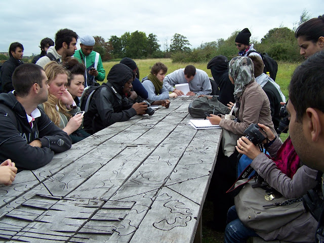
In preparation for our first walk next week, you should spend some time finding out about the area - the main issues affecting it, and getting an overview of the different territories. This knowledge will then inform your understanding of the place during the walk, when it will combine with a direct experience of your immediate surroundings.
The above film was made for this year's Open House weekend and is a very quick introduction.
The River Lea is also known as Lee and these spellings are used to refer to different parts and aspects of the river. The "upper" valley refers to the northern part nearer the source and "lower" valley to the southern part towards the Thames, but there is no clear definition for when one ends and the other starts. We will focus on the middle part of the valley between the boroughs of Hackney and Haringey on the west and Waltham Forest on the east.
The area is vast and there are many different organisations with interests at stake, including the local Borough councils, Thames Water (water supply and waste water), the Environment Agency (flood risk and environment), British Waterways (navigable waterways), the London Wildlife Trust (ecology), and the Lee Valley Regional Park Authority. The Authority manages the Lee Valley Park which was created by an act of parliament in 1966; it is 26 miles long, from beyond the M25 to the Thames.
The following three references are for extensive strategic documents - you are not expected to read all of each of them, but they give a good idea of the range of issues, the scope of the plans, the parties involved and a dizzying number of projects. Each covers the same geographic area but while there is some repetition between documents, the varying aims and approaches to the strategies are also revealed. Some sections are suggested. Download the pdfs where available but please do not print out except very selectively.
Upper Lee Valley Landscape Strategy
"... a hundred small stitches that need to be undertaken with knowledge of the valley's ecologies, and humility in design approach..." William MannThis study and strategy was carried out by Witherford Watson Mann Architects. It gives a good overview of aims and describes the existing and potential qualities of the area. Purpose and Aims pp6-7; As it is now pp14-17; Distinct areas of the Upper Lee in the context of the whole valley pp18-19; Tensions pp22-23; Vision pp26-33;
Download Strategy
Download List of Projects
Lee Valley Park Development Framework
“… a place for the occupation of leisure, recreation, sport, games or amusements or any similar activity, for the provision of nature reserves and for the provision and enjoyment of entertainments of any kind.” Section 12(1) Lee Valley Regional Park Act 1966Recently updated objectives, aims and delivery of the Lee Valley Park Authority. Online sections and sub-sections such as Environment section, including Water, Energy, Productive landscape.
East London Green Grid
Vision: To create a continuous and accessible spine of open space along the course of the River Lea, from the River Thames to the rural Hertfordshire and Essex. This will ensure people can readily access that open space through the creation of multiple high quality routes to and through the open space spine.Download the Primer and Area Framework 1: Lea Valley. The primer contains eight short essays, of which the first, second and fifth are particularly relevant. The last is a photo essay. The Area Framework combines strategy and project details - note the consideration of timescales, funding and different client bodies for the projects. Area Framework: Area Description p8; Objectives pp12-13.
The London section in landscape journal Topos Issue 75 has several interesting articles. In the Docklands library journals collection or download here.
23 September 2011
current events
Keep an eye on the section "Happenings" on the right where we will keep a list of current exhibitions and events that are relevant to the unit and of general interest. You should make an effort to see these, and let us know of any others we can add.
More information on the first three selected:
This year's Serpentine Pavilion by Peter Zumthor and Piet Oudolf explores many of the ideas we will be looking at this year; you should spend some time in an around the pavilion observing how it is occupied and how it performs, taking note of how edges are treated and boundaries explored, as well as the role of nature.

Detail from The Cut, by Jessie Brennan
The Jerwood Drawing Prize is an annual open-entry competition; the finalists' exhibition is always worth seeing for an inspiring variety of drawing and interpretations of drawing.
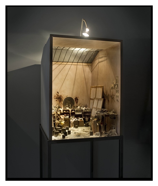
Francis Bacon's Studio, by Charles Matton
The Charles Matton exhibition is a series of meticulously detailed miniature interiors, which show one aspect of what is possible with architectural models.
More information on the first three selected:
This year's Serpentine Pavilion by Peter Zumthor and Piet Oudolf explores many of the ideas we will be looking at this year; you should spend some time in an around the pavilion observing how it is occupied and how it performs, taking note of how edges are treated and boundaries explored, as well as the role of nature.
Detail from The Cut, by Jessie Brennan
The Jerwood Drawing Prize is an annual open-entry competition; the finalists' exhibition is always worth seeing for an inspiring variety of drawing and interpretations of drawing.
Francis Bacon's Studio, by Charles Matton
The Charles Matton exhibition is a series of meticulously detailed miniature interiors, which show one aspect of what is possible with architectural models.
20 September 2011
wilderness on the edge of town
This year Unit G will explore architecture as a catalyst and component of processes and cycles, both ecological and infrastructural. We are interested in the relationships between body, movement and landscape, and between city and nature.
The unit will investigate edge conditions and issues of scale within the context of the Lea Valley; containing London’s second river and dividing both the local area and East London with a series of boundaries at local and wider scales. This inner edge is neither urban nor rural, and occupies the margins of the city where historically infrastructural and industrial activities were relegated. The area contains a fragmented collection of some of the most striking landscapes of London.
The increasing priority of issues of resource management, waste and energy provides the future context for us to speculate on a localised, human scale of utilities and services that might allow a reconnection between society and necessary infrastructure. We seek to exploit the qualities of these structures and processes, focusing on inhabitation by people and other species.
Subscribe to:
Posts (Atom)